- AVL Systems Software
- Specific software “GUARDTrack” provides polling, messages receiving, communication line control and also work with mobile assets. Software also allows filtering multiple repetition of one message from vehicle that is received by different channels (1-8 channels GSM900/1800 and 1-2 channels ORBCOMM).
- Software performs system control, is data interface for vehicles, provides location report, sends image of tracking map to system and ensures functioning of dispatcher workplaces.
- There is an extra possibility to configure completely each segment of the system. Command set allows system administrator to configure all data transmission ports, create and delete objects, modify information in database, change configuration and network parameters to control communication channel and system configuration.
Using these commands, user can display on monitor parameters of specific vehicle unit:
- Number, Class, Status, Speed of vehicle.
- Distance from the nearest known point
- Message
- Message reception time
- Status of on-board alarm system
- Direction of movement
- Coordinates of object (latitude and longitude).
There are commands for immediate receipt of specific vehicle information without looking for it in the list.
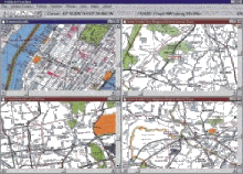
Software provides display of vehicle location and it’s status on the electronic map. Several areas of the map can be displayed on the monitor simultaneously. Each map is configured individually within a separate window in order to display different lines, scale, viewport, selected messages on the status of vehicle. As each window allows displaying of nay part of the map, which is stored in database, the viewport of the map may be chosen to display the map in whole, its limited area or a certain terrain area. In order to supervise the work of the vehicle a special window may be opened. With the help of this window it is possible to control and monitor a separate vehicle or a group of vehicles. He operator can select the area he is interested in, to zoom and to center the image relatively to the chosen point.
If the map was created for monitoring of vehicle or group of vehicles, the window will zoom and move the image automatically in order to keep the vehicles constantly you are interested in within window limits. With the help of standard utilities the size or screen location of each window with map can be changed. Other possibilities of manipulation with map includes "find vehicle" utility, which is used for fast finding of location and displaying of a certain transport unit, and utility which provides displaying the base, in order to help dispatchers in fast orientation when making decisions.
In addition to displaying the status of transport facility, in temporary working window within map image, text information about each object, including identifier of transport unit, direction of the traffic, speed, time, etc.
- NOTICE: It is possible to apply For fleet management and navigation applications such as vehicle tracking, mobile data, car navigation, Automatic Vehicle Location (AVL) any specialized software.
|Main Page| |Introduction| |Dispatcher Center Equipment| |AVL System Software| |The Kit of On-board Transport Equipment| | The Kit of On-board Transport Equipment - next page|
(C)opyright Transexpo corporation. All right reserved.